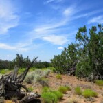
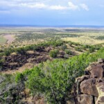
PROPERTY DETAILS
Size (Acres): 72.1
General Location: Near Apache County Road 7395, Sanders, AZ
APN or Other ID: 20769004 & 20769005
Subdivision: N/A
Legal Description: The NW corner of Section 21, T 20 N, R 28 E and Parcel #2, Flowing Wells of Section 21, T 20 N, R 28 E of the Gila and Salt River Base and Meridian, Apache County, Arizona
Approx. GPS: Click Here for Directions
35.125375, -109.372700
35.121646, -109.372570
35.121678, -109.365662
35.125334, -109.365780
Property Type: Rural Land
Zoning: General Agricultural. For more information, contact Apache County 928-337-7526 or visit their website www.co.apache.az.us.
HOA/POA Fees: No
Terrain: Varied with Washes
General Elevation: Approx. 6,100
Power: Power poles close, the neighbor to the west has power, or would be by generator, solar or wind
Phone: Mobile/Satellite/Alternative
Water: Would need to drill well or use alternative system
Sewer: Would need septic or alternative system
Roads: Dirt (4wd recommended)
Time to Build: No Limit
Title Info: Clear Title, Conveyed from LG Solutions LLC
Annual Property Taxes: Approx. $90
Doc Fee: $399
Terms: Cash or Payments


